 |
|

|
|
Research | Concepts | MId-Ocean Ridge EM Exploration
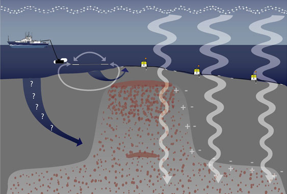
At a fast spreading mid-ocean ridge such as the East
Pacific Rise, marine
EM can be used to characterize the magmatic and hydrothermal systems.
Seafloor electromagnetic
receivers are used to measure natural source time variations in Earth's
magnetic and electric fields for the magnetotelluric
(MT) method, which yields electrical conductivity structure from depths
of less than 1 km to a few hundred kilometers. Higher current densities are
induced in conductive structure and so the MT method is preferentially sensitive
to conductive features such as partial melt and hydrothermal fluids.
For the
controlled-source or active-source EM method a horizontal
electric dipole antenna is towed close to the seafloor and transmits
a few hundred amps of current
into the seafloor at frequencies of 0.1 to 10 Hz. The transmitted electric
field travels through both the seawater and the seafloor. Because seawater
is usually more conductive than the seafloor, the electric field in
seawater attenuates away more rapidly. Thus the measured field on
the seafloor EM receivers is that
of the field that travels through the subsurface. The spatial character of
the attenuation of the measured EM fields yields information
on the subsurface conductivity structure. Because the electric field propagates
to larger distances for more resistive structures, the controlled-source EM
method is preferentially sensitive to resistive features. The penetration depths
are less than for the MT method, so controlled-source EM is more suited to
mapping structures at crustal depths.
|
|
|
|
|
Last updated: Wednesday, 06-May-2009 14:40:13 PDT
email: sconstable@ucsd.edu
|
|

